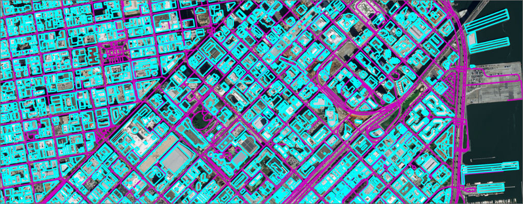
Solutions For Mobility And Logistics

Critical data and tools for high-definition mapping

Navigating beyond the horizon

Today, vehicles have sensors that detect their surroundings and identify potential hazards. Improving safety requires a foundational map that goes beyond the vehicle vicinity. We help automotive companies build proprietary maps, providing the flexibility and privacy to evolve their autonomous programs at their own pace.

Driving autonomous technology forward

If your organization is making investments in high-definition (HD) maps for advanced driver-assistance systems, semi-autonomous or autonomous technology, Maxar Intelligence's satellite imagery and road network data provide flexible, tailored data that fits any workflow.

Increase route efficiency

Turn-by-turn and step-by-step, your maps matter. Providing navigation systems with accurate mapping data is essential for efficient routing. Maxar’s remote sensing and derived geospatial data products help logistics planning teams move product around the world in the most efficient way possible—saving time, resources and lives.

Learn more

Choose a partner, not a vendor

Maps are at the center of mobility technology—from apps to autonomous vehicles. Maxar assists partners at all levels, delivering global high-resolution satellite imagery and derived geospatial data. 

Whether your organization ingests direct, raw data or needs user-ready imagery products, Maxar has your content. We can help you transform operations without sacrificing valuable intellectual property. 

Safety first, autonomy second

Transform your customer experience

Map icon

HD mapping

High-quality geospatial data provides reliable information on lanes, road markings, features, road furniture and more. Build your own HD maps and autonomous technology with frequent updates, current imagery, change analysis, feature extraction and 3D data from Maxar.

Learn more
Change icon

Reliable change detection

Monitor changes on roads, including new lanes, intersection changes, construction, hazards, lane modification and traffic flow disruption, with near real-time alerts from Maxar change detection capabilities powered by artificial intelligence (AI) and machine learning.  

Thumb icon

Superior user experience

Publish location information in dash with reliable route preview and pickup and drop-off points built with 3D data over Maxar high-resolution imagery for superior user experience.   

Automotive icon

Logistics productivity

Improve efficiency and reduce time required for deliveries by leveraging off-the-shelf geospatial solutions from Maxar.

Shield icon

Protect your data

Work directly with the data source to create a competitive differentiation in your HD mapping programs with a proprietary solution.

Relevant products

Satellite imagery

The fidelity of Maxar’s 30 cm-class imagery lets you build more accurate maps and gain greater clarity.

Learn more

Maxar® Geospatial Platform (MGP)

We collect about 3 million sq km of high-resolution imagery each day, continuously feeding our 20-year, 125+ petabyte global imagery archive.  

Learn more

Precision3D™

Access high-resolution 3D and elevation models to provide a digital twin for a more complete picture of the situations that matter to your organization. 

Learn more

AI-enabled analytics

Combine high-resolution imagery with AI and machine learning tools to extract features and identify attributes—like building footprints and road furniture—at scale.  

Learn more
satellite image of urban area with derived analytics overlaid on the image

The road to autonomy is paved with geospatial data

Maps are a foundational component in vehicle navigation. Take a look at how satellite imagery fits in at every level of autonomy and how geospatial technology is key to moving from Level 3 to Level 5: full autonomy.

Learn more

See For Yourself

Experience the clarity and accuracy of the industry’s highest quality geospatial data. 

Learn more